")
Sub-Total: $0.00


Lake Crowley Map
$12.95
Description
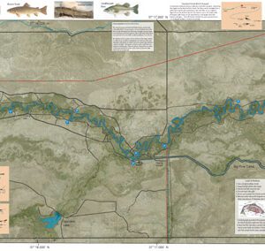
Lake Crowley Map covers the water of Lake Crowley. The map shows lake topography, GPS Long./Lat., camping areas, road access, and below-surface stream channels. Also with Special Features such as Suggested Flies, Midge Rigs, Streamer Tactics, Fishing Season and Regulations, Fish Identification, Where to Fish, Catch & Release Procedures, and Stream Etiquette guidelines.
Lake Crowley Map is best fished from a boat or float tube. There are times during the Fall when the fish are close to shore and you can fish from shore as well. The fish are Rainbows, Browns, Lahontan Cutthroats, and plenty of Sacramento Perch. Try to locate the old channels, particularly in McGee Bay. Midging works well year round and there is a good damsel hatch in the early Summer. Streamer presentation work well during the Fall when the trout are chasing the perch fry.
For additional information on the Owens River that feeds Crowley Lake, see the website.