")
Sub-Total: $0.00


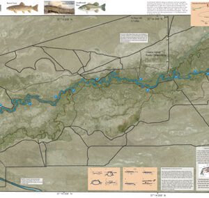
Upper Owens 1
$12.95
Description
Upper Owens 1 covers the Owens River between the mouth of Crowley Lake to Benton Crossing Bridge. Satellite photo background depicts vegetation surrounding the river. Shows camping areas, GPS Long./Lat., road access, trails, and fences. Access through the Stream Fence are shown. Special Features are the Hatch Chart, Fishing Season and Regulations, Fish Identification, Catch & Release Procedures, Nymphing Rigs, Knots, and Stream Etiquette guidelines.