")
Sub-Total: $0.00


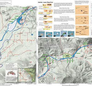
Pine Flat Lake Map
$12.95
Description
Pine Flat Lake map covers the water of Pine Flat Lake near Fresno. Shows camping areas, road access, trails, and below-surface stream channels. Special Features are Suggested Carp Flies, Fishing Season and Regulations, Fish Identification, Where to Fish, and Stream Etiquette guidelines.
Pine Flat Lake map shows over 43,000 acres with 67 miles of shoreline. Springtime when the trout are chasing the shad near shore is the best time for fly fishing with stillwater techniques. Using the float n fly technique is also excellent during the early summer for Largemouth and Spotted Bass.
For more maps of the Kings River, visit the website.